Beyond London
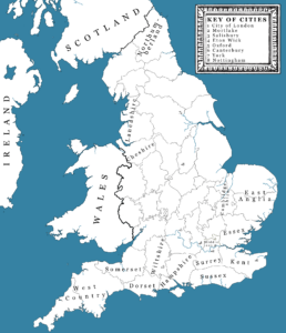
Although most of The Merchants of London series takes place in and around the City of London, there are other places within England, Beyond London, that are important to the story. A summary of the key ones is given below.
Mortlake
Situated on the south bank of the River Thames, Mortlake was approximately 12-14 miles west of the City of London.
It was a significant area during the 17th century thanks to its proximity to London and its closeness to Richmond and the royal estates. As a result, it attracted members of the aristocracy, merchants, and other influential families, especially those with connections to the royal court.
Prior to the Civil War, Mortlake was primarily a rural village known for its scenic location. It was home to a population of around 1,000–2,000 people (estimates vary) and the parish was centred on St Mary the Virgin Church. There were several large estates owned by gentry, clergy, and merchants, including members of the Juxon family (the family at the centre of the series).
The river was key to life in the village, and houses and businesses were more densely settled along the riverside. Notable on the waterfront were the numerous stairs, and the boats and wherries that transported the many people coming and going, both from the east and west.
Mortlake was also famous for the Mortlake Tapestry Works, a major tapestry manufacturing business established in the late 16th century.
During the war, it came under Parliamentary control. Although it was spared the destruction seen in other parts of England, villagers would have experienced the constant movement of soldiers, increased taxation, and the requisitioning of horses, carts, and supplies. Troops, messengers, and supplies frequently passed through on the road between London and Kingston, while the Thames carried military stores and provisions.
Windsor / Eton Wick / Boveney
Each of these locations was situated to the west of London, close to the River Thames.
Windsor was a relatively small but important market town approximately twenty-five miles from the City. It was situated on the southern bank of the river, and the landscape was dominated by the presence of the royal castle.
Most of the houses occupied by the 1,500–2,000 inhabitants were clustered beneath the walls of the castle around the castle hill.
A timber bridge connected Windsor with Eton on the north bank of the Thames. Immediately across the bridge stood Eton College, the well-known English public school that was founded in 1440. In the 1640s, it was already one of England’s leading schools, and many sons of noble and gentry families were educated there.
Prior to the war, King Charles fled to the castle at Windsor, but once he left in 1642, it was taken over by Parliamentary troops. For the remainder of the war, it became one of Parliament’s principal fortresses guarding the approach to London from the west. Towards the end of the war, the castle briefly became Charles’s prison, and ultimately in 1649 he was buried in the castle’s St George’s Chapel.
Eton Wick was less than two miles from Eton itself but was very different. In the 1640s it was little more than a hamlet lying on the road west from Eton to the small village of Dorney.
It probably only contained a few dozen houses, mostly timber-framed cottages, small farmhouses, barns and agricultural buildings.
Boveney lay about 2 miles south-west of Eton and directly south of Eton Wick. It sat on low ground beside the Thames and was a tiny rural parish comprising little more than a handful of farmsteads, cottages and its parish church, St Mary Magdalene. The church, though small, was the focal point of parish life.
The impact of the war on both Eton Wick and Boveney was less significant than Windsor, but both will have experienced the war more indirectly through troop movements, increased taxation, requisitioning of supplies, and the constant awareness that the conflict was unfolding only a short distance away.
Wiltshire / Salisbury
In the 1640s, the County of Wiltshire was a green and gently rolling county, dotted with villages, fields, and the country estates of ancient, landed families. Families we might today call the landed gentry.
It contained the houses of both the gentry and the nobility, many of whose families had been established there for generations and whose estates shaped local society and politics.
Wiltshire was characterised by broad, open expanses, especially around Salisbury Plain, and chalk downs that supported large flocks of sheep. The wool trade was central to Wiltshire’s prosperity.
Ancient monuments such as Stonehenge and Avebury were already part of the landscape and well known locally.
It was also a county of market towns, with places such as Salisbury, Marlborough, Devizes, and Chippenham serving as centres for trade, justice, and local administration.
Salisbury was also well known for its Cathedral. Its exceptionally tall spire dominated the surrounding landscape and was one of England’s most recognisable ecclesiastical landmarks.
During the Civil War, Wiltshire gained a reputation as a strategically important county. Its position between London, the West Country, and the King’s wartime capital at Oxford meant that armies repeatedly marched across it.
Salisbury declared for Parliament early in the war, and although it remained under Parliamentary control throughout the war, Royalist forces threatened or approached Salisbury on several occasions. There were periods of anxiety when nearby Royalist armies operated in Wiltshire and Dorset, but the town itself did not become the scene of repeated sieges or changes of occupation.
Somerset
A neighbouring county to Wiltshire in the west, Somerset was characterised by having smaller fields than its neighbour with more hedgerows, trees and wooded patches. It would have given the feel that the villages were closer together.
The south-east of Somerset (close to the Wiltshire border) had a feel of old county families embedded among long-settled villages and farmland.
During the war, loyalties amongst the local population were divided, and many tried to remain neutral, at least initially, to protect their estates and tenants. This became harder as the war intensified, not least because, due to its location, armies repeatedly marched through the district on route to Wiltshire, Dorset, Bath and Bristol.
For the landed gentry in the area, if they openly supported one side or the other, they risked significant consequences such as fines, sequestration of their estates, arrest and/or visits from hostile troops.
Oxford
Prior to the war, Oxford was one of England’s most important provincial cities. There was a population of around 8,000–10,000 people, but first and foremost it was a university city. Dominated by its colleges, scholars, and churches, it was also a cathedral city where clergy were a common sight, and religious observance was woven into daily life.
Despite its academic reputation, Oxford was also a working town with busy markets, inns and taverns, booksellers, printers, tailors, shoemakers and other craftsmen who served both the townspeople and the university
Oxford lay on the main roads between London, the Midlands, Wales and the West Country, making it an important staging point for travellers, merchants, lawyers and clergy who regularly passed through.
Life for people in the city changed, however, in October 1642 when King Charles, who had by then fled London, made Oxford his new capital city.
There were numerous reasons why Charles picked Oxford, but key amongst them included:
It was only about sixty miles from London.
- It possessed substantial stone buildings capable of housing government offices and leading nobles.
- The colleges had halls, libraries and accommodation that could be adapted for administration.
- It was naturally defensible, lying between the River Thames and the River Cherwell.
- The surrounding counties were initially favourable to the King’s cause.
Albourne Place, Sussex
Albourne Place was a significant country estate in Sussex. It was bought in 1639 by the brother of William Juxon, Bishop of London, and at the time, would have symbolized the Juxon family’s wealth and status. It is known to have been used by the bishop, and tradition suggests that he used the house as a place of refuge following the execution of King Charles.
Today, Albourne Place remains one of the most important historic houses in the parish of Albourne, West Sussex. It is a Grade II listed building, placing it among the top 6% or so of listed buildings in England in terms of architectural and historic importance.
Little Compton, Gloucester
Little Compton is a village and civil parish that was originally a detached exclave of Gloucestershire, but which was transferred to Warwickshire in 1844.
It has origins dating back to the 11th century or earlier and was recorded in the Domesday Book (1086), as having a population of approximately 80 households. Among these, the manor and church were part of an endowment given by King Edward the Confessor to the Abbey of St. Denis in Paris.
By the time of the Civil War, or shortly after, the estate became the private property and manorial residence of Bishop Juxon.
During the interregnum, when Oliver Cromwell was leading the country, the bishop fled to the parish and appears to have lived in strict privacy and retirement, well away from the ill-will of the usurpers of the government.
Little Compton Manor still stands today and is a Grade II listed Elizabethan house, although it was remodelled around 1620. While the private historic house is closed to the public, its grounds are open to the public at selected times of the year.