The City of London - Within the Walls
At the time of the English Civil War in 1642, much of the City of London was still within the old walls of the medieval city. It covered approximately 1.06 square miles and is essentially the same area that is now referred to as the ‘square mile’, the famous financial centre of the UK.
The City wall ran from Blackfriars in the west, as far as Cripplegate in the north-west. It then continued to Bishopsgate in the north-east, before heading back down the east side of the City, past Aldgate and on to the Tower of London (which was just outside the walls). To the south, the City is bordered by the River Thames.
City Layout
Entry into and out of the City was controlled though a series of gates. There were seven main land gates and one water gate. From west to east, the gates were:
- Ludgate
- The southwestern entrance leading to Fleet Street, Strand and the Palaces of Whitehall and Westminster.
- Newgate
- The western route toward Oxford and the west country. The gatehouse itself and adjacent buildings formed part of the famous Newgate prison.
- Aldersgate
- An important route toward Smithfield and the north-west.
- Cripplegate
- Gave access to the northwestern suburbs as well as Moorfields and Finsbury Fields.
- Moorgate
- The newest of the major gates created in the 15th century to improve access to the Moorfields area and Finsbury Fields.
- Bishopsgate
- Named for the Bishops of London, this led north toward Shoreditch and Cambridge.
- Aldgate
- Eastern entrance toward Essex and East Anglia.
- Billingsgate (the water gate)
- This was situated to the east of London Bridge and was a principal opening onto the Thames. It was more a riverside gate and landing place than a defensive City gate.
As described in the article on the governance of the City HERE, the City was divided into twenty-six wards. Most of these wards sat within the walls, but as the population of the City grew, some spilt out into the area outside the walls. These outer areas retained the name of the ward from which they were governed but were distinguished as being beyond the walls by adding the suffix ‘Without’ to the ward name. For example, Cripplegate was correctly referred to as Cripplegate Within (inside the walls) and Cripplegate Without (outside the walls)
As is still the case today, the main areas of power in England were the Palace of Whitehall (in the 1600s home and offices for the King and his officials) and the Palace of Westminster (the seat of Parliament). These sat approximately two miles outside the City walls to the west and were most commonly accessed via the gate at Ludgate, Fleet Street and Strand.
In 1666, several years after I plan to end the series, London was ravaged by the Great Fire of London. Approximately 80% of the walled City, and a sizeable area to the west, around Fleet Street, was destroyed. Area’s least affected where to the east, and far north of the City. This means that most of the buildings described in the series, and those used on the book covers, are the original medieval buildings and not the buildings we see today.
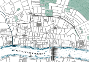
To highlight key places in the series, I’ve produced the map above. I’ve taken the details from a map that was drawn shortly after the Great Fire by Hollar. Although it’s shocking to see how much of the old City was destroyed, it has proved useful in my research to identify street names and places. They are much clearer on this map compared to others, due to the lack of buildings. If you’d like a closer look, you can find the original map HERE.
Places of Note for The Merchants of London*:
St Paul’s Cathedral. By 1641, the medieval St Paul’s Cathedral was one of the largest and most imposing buildings in England. Sitting close to Ludgate the cathedral was a vast Gothic building of pale stone. It stretched over 580 feet (177 m) in length and at its centre stood a massive square tower topped by a relatively low spire. The original spire was one of the tallest in Europe but was destroyed by lightning and fire in 1561 and not rebuilt.
The building was one of the most high-profile losses of the Great Fire and the building. The Cathedral that stands on the same site today is the replacement, which was designed by Sir Christopher Wren.
St Paul’s Churchyard. The area around the cathedral was crowded with buildings, booksellers’ stalls, and monuments, making the cathedral appear embedded within a dense urban landscape.
Royal Exchange. Opened 1571, the Exchange stood on Cornhill in the heart of the City’s merchant district. It was one of the most important commercial buildings in London and served as the principal centre for wholesale trade and finance in England. It functioned as a meeting place where merchants exchanged information on shipping, commodities, insurance, and overseas markets.
The original building was a large rectangular Renaissance-style building of stone and brick that was built around a spacious open courtyard. It was destroyed in the Great Fire. The current Royal Exchange is built on the same site.
Guildhall. One of the most significant public buildings in England, the Guildhall was the political and administrative centre of the City of London. It served as the headquarters of the Lord Mayor, aldermen, and Common Council of the City and was also a venue for civic ceremonies, elections, banquets, and legal proceedings. During the civil war, it was an important centre of London’s government and a meeting place for citizens involved in national affairs.
The building itself was a large medieval Gothic building dating mainly from the 15th century. It was dominated by its vast Great Hall, with high stone walls and an impressive timber roof.
Although, much of the surrounding area burned during the Great Fire, the Guildhall was one of the few major buildings not destroyed. Because the main structure remained standing, the Guildhall is one of the few major public buildings in the City that preserves its medieval history.
Cornhill, Lombard Street and Threadneedle Street. By the 1640s, these three streets formed the commercial heart of the City of London. If St Paul’s represented religion and Guildhall represented civic government, these streets represented money, trade, and communications. Together they contained many of the institutions that connected London to the rest of England and the wider world.
Of note:
-
-
-
- Cornhill was one of the oldest and busiest streets in London, running eastward from the area around the Royal Exchange. It linked the Exchange with other important trading districts and was home to merchants, goldsmiths, money changers, and traders who maintained premises along its length.
-
- Lombard Street was London’s financial district before the existence of modern banks. It was the centre of money lending, credit, foreign exchange, and merchant banking meaning many wealthy goldsmiths and international merchants operated there. The area was a combination of large merchant residences and business premises.
-
- Threadneedle Street lay immediately north of the Royal Exchange and was closely connected with the mercantile and financial activities centred on the Exchange. It contained important merchant houses, trading offices, and parish institutions and later (1694) became famous as the home of the Bank of England, which is there to this day.
-
-
Cheapside was the principal shopping street of London and one of the busiest and most prosperous places in England. If Lombard Street was where money was financed, Cheapside was where wealth was displayed and spent. Wealthy tradesmen had shops there, including goldsmiths, jewellers, mercers, silk merchants, drapers, and haberdashers.
It connected the commercial City to the political and legal centres further west (beyond the City walls), and important civic processions, royal entries, and public celebrations often passed along the street. Unfortunately, Cheapside lay directly in the path of the Great Fire of London meaning most of its houses, shops, churches, and market buildings were destroyed. The street was ultimately rebuilt with wider roads and more brick and stone construction.
Coleman Street. Although it was less than a five-minute walk from Cheapside, Coleman Street was not as wealthy or prestigious as Cheapside, Cornhill, or Lombard Street. It was, however, politically important in the 1600s, having a reputation for religious nonconformity and radical opinion.
Located in the north-central part of the City it ran north from the area near the Guildhall towards the city wall. It was part of a densely populated district of merchants, craftsmen, shopkeepers, and lesser traders, and became a place where commercial interests, religious conviction, and political activism intersected.
By the 1640s, Coleman Street had become associated with strong Puritan religious sentiment and in the years leading up to the English Civil War it was rife with political activism. It contained networks of merchants, citizens, and ministers sympathetic to Parliament who were opposed to some of the policies of King Charles I. Royalists often spoke of “Coleman Street” almost as a political label, using the name to refer to the more radical elements of London opinion.
Coleman Street and most of its buildings were heavily damaged or destroyed in the Great Fire of London. The parish church of St Stephen Coleman Street, which had a reputation as being the centre of religious debate and dissent, was destroyed although it was later rebuilt under the supervision of Sir Christopher Wren.
Walbrook and the immediate area was one of the most historically significant and symbolically important parts of the early modern City of London. It had once been the central civic and religious core of the Roman Londinium but by the 1640s it was less commercially dominant than places like Cheapside or Lombard Street. Nonetheless, it was still strongly associated with ancient civic continuity and contained major churches, including St Stephen Walbrook and St Swithin London Stone.
The Walbrook (a river) ran in a steep, narrow valley from the north into the River Thames. It’s course created winding lanes, enclosed, shaded streets and densely packed property plots which were a mix of residential and business use
Many merchant houses, scriveners, and counting houses clustered in the narrow lanes feeding into the valley
Like nearby Coleman Street, parts of the Walbrook parish network had strong Puritan influence and some active parish communities were involved in City politics. It also had connections to merchants engaged in Parliamentary support
It is also important for The Merchants of London series, as several of the main characters have their business premises in Walbrook, and are also engaged in Parliamentary support.
As with most of the south of the City, much of Walbrook was destroyed in the Great Fire, although the church of St Stephen’s was later rebuilt.
Thames Street. As the name suggests, Thames Street ran (and still runs) parallel to the River Thames. In the 1640s it was effectively London’s waterfront service road, connecting dozens of wharves, quays, stairs, warehouses, and commercial premises. This made it one of the busiest and most economically important streets in England. It was also one of the most cosmopolitan places in England. A person walking along Thames Street in 1642 might hear English, Dutch, French, Spanish, Portuguese, or Scandinavian languages in the space of just a few hundred yards.
Unlike Cheapside or Cornhill, however, Thames Street was not a place people typically visited to stroll, shop, or participate in civic ceremony. Its character was overwhelmingly work orientated:
Although the whole street was tied to the river and maritime trade, different stretches had noticeably different characters:
-
-
-
- The western end was close to St Paul’s and the Blackfriars district. Although it still handled goods, it was also connected with cathedral traffic and legal and administrative business from nearby Blackfriars. Residences at this end of the street tended to be occupied by wealthy citizens and nobles.
-
- The central section, between Dowgate and London Bridge was perhaps the busiest stretch. It was at the heart of the City’s maritime economy and was crowded with warehouses, cranes and hoists, counting houses and merchant offices. Items that were imported included such things as wine shipments from France and Spain, timber from the Baltic. Spices and luxury goods arrived through the East India Company while sugar and tobacco arrived from the colonies. Coal was also shipped into the City from northern England. It was also used for the import and export of cloth.
-
- At the east end, around Billingsgate, the atmosphere changed again. This area was famous for fish landings, coastal trade and smaller cargo vessels. It was also close to the old customs house meaning it was particularly important for merchants engaged in international commerce.
-
-
The area was filled with crowds, such as fishwives, sailors and labourers. They were often rougher and more working-class than at the western end, and had a long-standing reputation for noise, strong language, and energetic bargaining.
In the early years of the civil war, the street became even more significant. Parliament’s control of London’s port meant they had control of Customs revenue, arms imports, overseas communications and supply networks.
This made Thames Street strategically important as well as commercially vital.
Old Swan Stairs and Old Swan Tavern. During the seventeenth century, the River Thames was often London’s fastest highway. Merchants, clerks, apprentices, and visitors could hire a wherry (a light rowboat) to take them east towards the Tower of London or west toward Westminster, Whitehall or the leafy suburbs beyond, such as Mortlake.
Access to the river was via stairs that were situated along the length of Thames Street and beyond. The Old Swan stairs were situated to the west of Old London Bridge. They were no more or less important than others but were a well-used and recognisable embarkation point. They remain a well-known feature of the riverside thanks to their appearance in diaries, correspondence, and literature from the time.
The Old Swan Tavern was the hostelry from which the steps took their name. It was a convenient landmark for arranging meetings and typically served travellers, merchants, sailors, and watermen. Both make appearances in the series!
London Bridge is the final landmark to highlight. At the time of the civil war, it was the only bridge crossing the river in the City.
Further details can be found here. Old London Bridge
* The Merchants of London is a fictional retelling of the ordeal, tensions and ultimate loyalty of three related families during the years of the English Civil War and subsequent interregnum.